

EXD56 is an outdoor waterproof multi-element low-altitude surveillance base station. The device adopts a modular design scheme. Users can flexibly configure modules such as Automatic Dependent Surveillance-Broadcast (ADS-B), UAV Remote Identification (RID), Global Navigation Satellite System (GNSS), and base station signal strength measurement according to their own needs, and can adapt to various integrated low-altitude surveillance solutions.
The device adopts a full aluminum alloy enclosure and a fiberglass antenna, adapts to various harsh environments such as wind, sunlight, rain, and snow, supports pole and wall mounting, supports Ethernet PoE or solar power supply, and multiple deices can be connected to a server to form a large-area airspace surveillance system. It can output in real time the identity and position information of various aircraft such as civil airliners, general aviation aircraft, and UAVs, as well as information sucn as GNSS signal strength and base station signal strength. The device can monitor UAVs within a maximum range of 5km, as well as general aviation aircraft and civil airliners within a range of 250km. It supports multiple protocol putputs, supports visual interface display, provides host computer configuration software, supports network remote configuration, supports remote firmware upgrade, and provides software custonization and technical support, convenient for use and maintenance.
Features
Powerful expansion capability, freely combinable with ADS-B/RID/GNSS/base station sibnal monitoring
All-round air situation surveillance, capable of detecting various types of aircraft
All-weather protection, 24-hour uninterrupted operation, aluminum alloy enclosure (IP66 waterproof)
Supports PoE power supply or solar power supply, convenient for deployment
Supports TCP/UDP communication protocols, supports 4G communication, easy to expang networking
Supports visual interface display, provides a low-altitude surveillance test platform
Application
Airport and critical infrastructure airspace surveillance
Air traffic control system (manned/unmanned aircraft cooperative management)
Urban traffic management (UTM) system
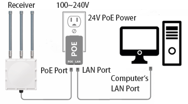
Hardware Connection

Technical Parameters
| Parameter | Min. | Typ. | Max. | Unit |
| PoE Supply Voltage | 24 | V | ||
| Solar/DC Supply Voltage | 8 | 12 | 28 | V |
| Power Consumption | 3 | 5 | 6 | W |
| WiFi 2.4G Receiving Sensitivity | -93 | -97 | dBm | |
| WiFi 5.8G Receiving Sensitivity | -90 | -95 | dBm | |
| Bluetooth Channel Receiving Sensitivity | -97 | -102 | dBm | |
| ADS-B Receiving Sensitivity | -90 | -95 | dBm | |
| GNSS Receiving Sensitivity | -150 | -160 | dBm | |
| UAV Target Processing Capability | 50 | sorties | ||
| ADS-B Target Processing Capability | 100 | sorties | ||
| ADS-B Range | 250 | km | ||
| Processing Latency | 10 | ms | ||
| Communication Interface | 10/100M auto-negotiation Ethernet port (PoE power supply) or LTE 4G wireless transmission (solar/DC power supply) | |||
| Power Input Interface | RJ45 (PoE power supply) or DC power jack (5.5*2.1mm, solar/DC power supply) | |||
| Network Protocol | TCP, UDP, MQTT (4G), HTTP (4G) | |||
| Mounting Method | Pole or wall mounting | |||
| Waterproof Rating | IP66 | |||
| Weight | Approx. 2.1kg (excluding fiberglass antenna) | |||
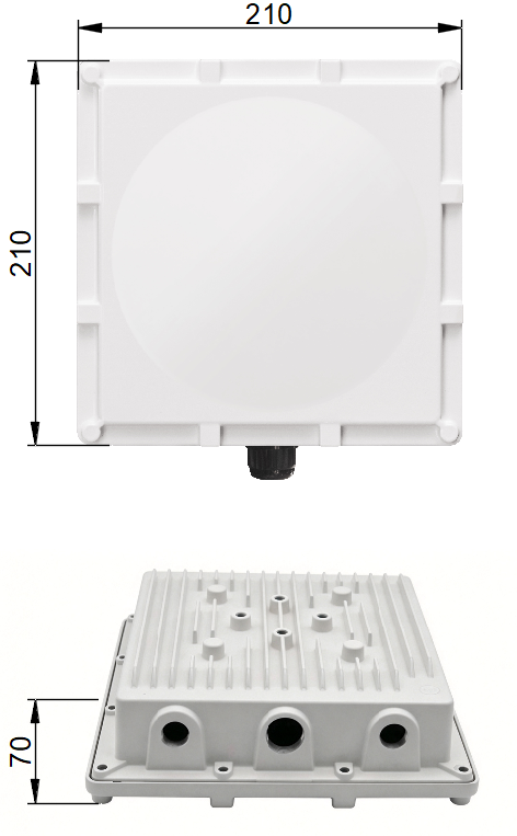
| Dimensions | 210*210*70mm (excluding bracket and antenna) | |||
| Message Format | Plaintext output, JSON format messages, low-altitude surveillance platform protocol messages | |||
Mechanical Dimensions (all units are mm)
Sales: Mr. Wang
Mobile/WeChat:
+86-136 3283 7835
E-mail: jaden.wang@exdtek.com
